Located just outside Fort Assiniboine, nestled between Highway 33 Grizzly Trail and the
Freeman River, lies the Freeman River RV Park. Owner/operator and Fort Assiniboine resident
Shaneen Beauregard has owned the park since buying the land in 2012 and also lives on the
land with her family.
During a Woodlands County Council meeting several weeks back, Beauregard expressed her
grave concerns over the movement of the Freeman River, its encroachment on her land, and its
eventual path towards the highway beyond her border. Beauregard wanted Woodlands County
Council to support her by applying to the Drought and Flood Protection Program to secure the
banks of the Freeman River. As a private landowner, she could not apply, but the municipality
could.
Beauregard presented the changes on her land over the years, including the devastation
suffered during last year’s flooding event, which completely changed the look and functionality
of her campground. “I have expressed the previous attempts for support throughout the years,
the displacement of my family since June of last year, the destructive risks to our community
and the potential threat that the river could have on our surrounding areas,” she began.
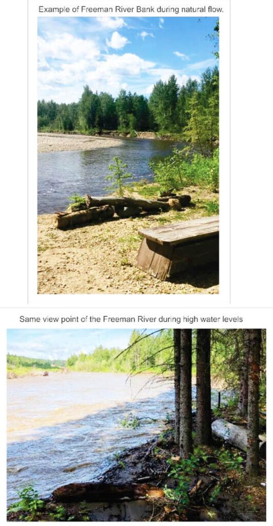
She provided images that showed the river when the flows were normal and comparisons
showing what the same area looked like after last year’s high water levels. She said the water
was approximately two meters higher. “I know this river well and have monitored water levels
and speeds for over a decade,” said Beauregard. “The Freeman River is now dredging through
my property, only 180 feet to Highway 33 Grizzly Trail.”
In 2023 alone, Beauregard lost over 200 feet of her property, swept away by the raging water.
“This explains the urgency to secure these banks. When the flow breaks through the bush line,
it won’t have anything to turn back on. It will be heading straight for Highway 33. This is not
considered overland flooding. It is dredging straight at it, like a T-intersection,” said Beauregard.
The Freeman River follows a winding path. The RV park sits at the upper point of a horseshoe
shape as the river turns dramatically toward land before turning back sharply in the other
direction, a U shape. Beauregard’s concern was that there might be nothing left to retreat the
water back in the next flood. She said the full flow would push inland, overwhelming Highway 33
and could move further into properties on the other side.
“It’s not the river just widening, it’s taking foot by foot (of land) because it’s only gravel and dirt.
Once it hits that 180 feet and goes through that bush, there’s nothing to turn it back. That whole
channel of river is going to be going down Highway 33,” warned Beauregard. “I know there has
been numerous amounts of flooding in the area, but it is a ticking timebomb,” she added.
Beauregard said after speaking with professionals and putting countless hours into securing
quotes and funding attempts to secure the bank, she believes the best course of action is to
place Gabion Baskets along the bank. “Gabion Baskets are one meter by one meter by three
meters and approximately ten thousand pounds each once they are filled with rocks. In some
areas, they would need to be stacked two or three high, and they would need to extend
approximately fifteen hundred feet along the riverbank from point A to B,” explained
Beauregard.
Beauregard said she had collected 142 signatures from area residents who supported
armouring the riverbank. She also invited Woodlands County Council members to visit her
campground and see the damage firsthand. “(The river) runs on a regular flow of six clicks (km).
In my last flood, it hit 390 clicks (km). How are you going to stop that? Once it pops through that
bush, that whole valley (will) be filled with water.”
Councillor Jeremy Wilhelm asked Beauregard if she had spoken to her MLA about the issue,
which she said she had. She added that she had been approved for her home and business
through the Disaster Recovery Program but that the program would not fund armouring the
bank. She said it felt like they were waiting for the water to hit the highway before doing
something about it.
When asked by the Council what they could do, Andre Bachand, then Acting CAO, said there
was not much since it was a provincial territory. “As far as what Council can do, I believe the
only thing you can do is talk to the elected MLAs and put pressure on them. We can’t speak to
the province as far as Highway 33 getting impacted and at what point they would step in. That
would be their call.”
Councillor John Burrows said diverting a river is one the toughest things to do. Looking at the
charts in Beauregard’s package, he honed in on the River Engineering and Technical Services
report from the Government of Alberta on the Freeman River Riverbank erosion. “Where the
current 2023 riverbank is and where the river park is that is all downhill to the highway, and then
through the highway is all downhill for another 700 meters. This is an Alberta-generated report
in 2023. So, they’re aware this highway’s coming out. It’s only a matter of time,” he said.
“In reality here, the province is either going to be building a multi-million-dollar bridge over this
thing, or they are going to be pushing to move this river or to keep it on the other side of the
highway,” said Burrows. He felt they needed to advocate for it. “This is at the very least
something we should be talking about with the province. I think we should at the very least be
writing some letters.”
Reeve Dave Kusch agreed with his colleague. He said painting a picture to the provincial
government of a proactive approach rather than a reactionary one would be good. “The costs
now will be minuscule (compared) to what it would be later on if we have to replace highways
and bridges or anything else.”
Woodlands County Council directed its administration to gather a list of relevant ministries and
MLAs and draft letters about the issue on the Freeman River, specific to Highway 33 and
Beauregard’s property, regarding mitigation work. “I’m sure everybody around this table here
can see the need for wanting to protect Highway 33 and the property in between. We will see
what we can do before it becomes a reactionary endeavour instead of something proactive,”
said Reeve Kusch. Any results from advocacy will be updated as information comes forward.


More Stories
Gearing up for another season of cars, cruising and camaraderie
Big dreams lead a talented local youth to Nashville
It’s Youth Week in Whitecourt until Friday